


11 June 2026
NTT and OIST expand observations from typhoons to linear rainbands and launch water vapor monitoring in the East China Sea

[Joint press release from NTT]
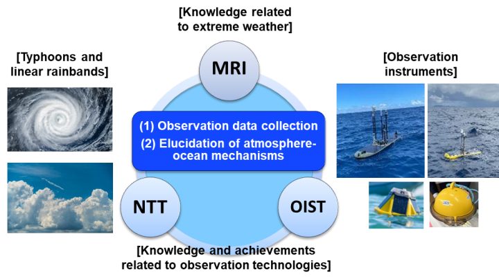
NTT, Inc. (Headquarters: Chiyoda-ku, Tokyo; President and CEO: Akira Shimada; hereinafter "NTT") and Okinawa Institute of Science and Technology (Onna-son, Kunigami-gun, Okinawa; Interim President and CEO: Daniel Zajfman; hereinafter "OIST") entered into a joint research agreement with the Meteorological Research Institute of the Japan Meteorological Agency (Tsukuba, Ibaraki; hereinafter "MRI") in May 2025.
In collaboration with MRI, NTT and OIST conducted atmospheric and oceanic observations in the waters surrounding the Okinawa Islands using autonomous, uncrewed surface vehicles and buoys, including operations in close proximity to multiple typhoons. The observations produced data capturing changes in atmospheric pressure, wind speed, seawater temperature, and other parameters, confirming the potential to improve typhoon intensity forecasts and enhance the accuracy of sea surface temperature data.
In fiscal year 2026, in addition to continuing typhoon observations, the organizations will expand the observation area to the East China Sea and undertake research aimed at advancing understanding of the formation and development processes of linear rainbands. By monitoring changes in atmospheric water vapor over the ocean, they seek to enable earlier forecasting of linear rainband events.
Background
In May 2025, NTT and OIST, which have expertise and operational experience in ocean-based typhoon observations, entered into a joint research agreement with the MRI, which has extensive expertise in extreme weather phenomena, to improve understanding of the role of the ocean in the formation and development of extreme weather events and to investigate the mechanisms behind severe phenomena such as linear rainbands and heavy rainfall associated with typhoons.*1
To address limitations of current satellite-based remote sensing, which has difficulty capturing conditions directly beneath typhoons and in areas where linear rainbands form and develop, the partners launched an observational research program to directly collect meteorological and upper-ocean data over the sea. The goal is to advance understanding of atmosphere-ocean interactions and the mechanisms that drive these extreme weather events.
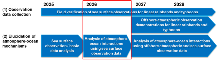
Now entering its second year,*2 the joint research project will further expand field observations during the flood season*3 by utilizing autonomous, uncrewed surface vehicles and buoys to collect meteorological and upper-ocean data within typhoon-affected areas.
Results from Fiscal Year 2025
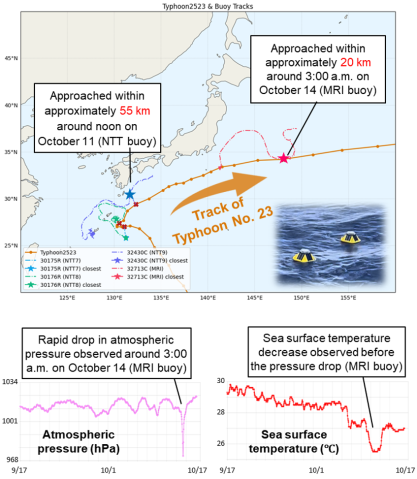
From June to September 2025, atmospheric and oceanic observations were conducted in the waters surrounding the Okinawa Islands. Autonomous, uncrewed surface vehicles were deployed to collect data in close proximity to Typhoons No. 7 and No. 8, while buoys recorded data associated with Typhoons No. 12 and No. 23.
Surface observations over the ocean captured rapid decreases in atmospheric pressure, increases in wind speed, and changes in wind direction as typhoons approached (Figure 3). Notably, the observations detected changes in sea surface temperature before and after typhoon passage, a key factor influencing typhoon intensification and weakening.
In addition, MRI has been developing an experimental environment and initiating preliminary forecasting studies using data collected through the joint research project. In experiments aimed at forecasting typhoon intensity, researchers incorporated predictions of sea surface temperature and subsurface ocean heat content generated by an ocean forecasting system that assimilates ocean observation data. The results showed cases in which accounting for typhoon-induced sea surface cooling improved the accuracy of maximum wind speed forecasts.
These findings demonstrate the potential of observational data to enhance the accuracy of sea surface temperature information and improve typhoon intensity forecasting. Going forward, the partners will continue leveraging observational data to advance understanding of atmosphere-ocean interactions occurring across the ocean surface interface.
Scope of the Initiative
A linear rainband is a meteorological phenomenon in which well-developed rain clouds align in a band-shaped formation, producing intense rainfall over the same area for an extended period. Heavy rainfall associated with linear rainbands is driven by large amounts of water vapor transported from the ocean. In particular, linear rainbands that occur over Kyushu are known to be influenced by warm, moist air flowing in from the East China Sea.
In fiscal year 2026, the observation area will therefore be expanded to the East China Sea, where atmospheric water vapor over the ocean will be directly observed. Detailed observations of water vapor over the ocean remain limited, and this lack of data is one of the challenges in improving the forecasting accuracy of linear rainbands. The new observation campaign is expected to help address this data gap and provide valuable insights for forecasting research.
Building on the results obtained in fiscal year 2025, the following activities will be undertaken in fiscal year 2026:
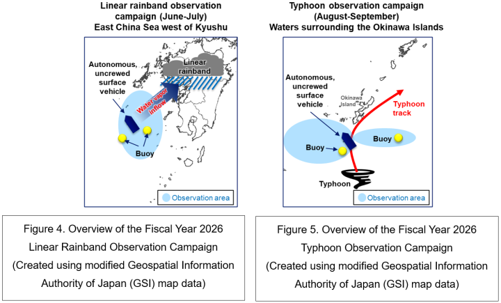
- New initiative: Observation campaign targeting linear rainbands over the East China Sea. Water vapor transported into the Kyushu region will be measured and analyzed to advance understanding of the formation processes of linear rainbands and improve rainfall forecasting accuracy (Figure 4).
- Continued typhoon observations in the waters surrounding the Okinawa Islands. Observation data collected around typhoons and along their projected paths will be analyzed to deepen understanding of typhoon formation and intensification processes, with the goal of improving forecasts of typhoon intensity and track (Figure 5).
Future Outlook
Through their joint research with the MRI, NTT and OIST will continue to directly collect meteorological and upper-ocean data in marine environments to advance understanding of the formation and development processes of extreme weather phenomena, including linear rainbands and typhoons. By leveraging these observational data, the partners aim to contribute to a deeper understanding of atmosphere-ocean interactions and the mechanisms that drive extreme weather events.
In particular, by capturing the spatial structure and high-resolution distribution of water vapor inflows, a key factor in the formation of linear rainbands, the research is expected to improve the forecasting accuracy of both linear rainbands and typhoons. Enhanced forecasting capabilities could help enable earlier evacuations and more effective disaster preparedness measures by local governments and residents.
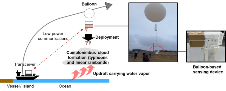
NTT is also conducting demonstration trials of a low-cost observation technology that combines balloons with low-power wide-area (LPWA) wireless communications (Figure 6). If meteorological data can be collected from above the ocean, the technology could provide detailed insights into atmospheric conditions over marine areas where observations have traditionally been difficult to obtain.
At OIST, experts and researchers from a wide range of disciplines, including meteorology, oceanography, mathematical sciences, and data science, are working together to promote interdisciplinary research. By integrating domain expertise with cutting-edge scientific knowledge, OIST seeks to deepen scientific understanding of ocean-atmosphere interactions.
Looking ahead, the partners aim to realize a marine observation platform that is essential for Japan as a maritime nation and to further advance research and development aimed at improving the accuracy of extreme weather forecasting.
【Glossary】
*1 “NTT and OIST to Launch Joint Initiative with Japan's Meteorological Research Institute to Improve Extreme Weather Forecasting” (June 3, 2025) https://group.ntt/en/newsrelease/2025/06/03/250603a.html
*2 Fiscal Year 2026 Press Release by the Meteorological Research Institute https://www.mri-jma.go.jp/Topics/R08/080605/080605_press.html (Japanese)
*3 Flood Season The period of the year during which river water levels are more likely to rise due to rainfall, snowmelt, and other hydrological factors.


